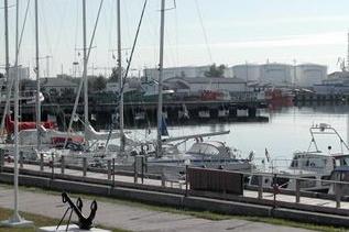
Ventspils
Ventspils Jahtklubs
Specification
| Coordinates | 57°24' N; 21°32' E |
| Postal address | Ventspils Jahtklubs, Medņu iela 40, Vetspils, LV-3600 |
| Phone | Mob.+371 28311919; Harbour Master +37126518421 |
| ventspilsmarina@nym.lv | |
| Website | www.ventspilsmarina.lv |
| VHF Channel | Ch. 9 |
| Capacity of Berth | 35 boats, 110m berth |
| Depth on approach | 14 m – 6.5 m |
| Depth alongside | 3.6 m |
| Neighbouring Marinas | Pavilosta - 35 NM, Roomassare – 60 MN, Roja – 65 NM |
| Public Transport | Bus services to Liepāja and Rīga |
| Directions for approach | From Safe water buoy “B “ (57°28.52' N 21°25.91' E ) proceed along the Ventspils Nothern Leading Line 143.7° T up to the entrance of fishing harbour (57°23.7' N 21°32.3' E ), then turn to starboard in this harbour to the berths on the starboard side. |
| Services | Electricity, Fresh water, Fuel from petrol station, WC, Showers, Sauna, Loundry, Bke rent, Winter outdoor yacht storage, Hotels and Shops in vicinity |
